Changzhougou Fm
Type Locality and Naming
Jixian County, Tianjin. The Changzhougou Fm was named at the "On-the-spot Symposium on the Subject of Sinian System" sponsored in Jixian, in 1964. The type locality is Changzhougou, 20 km north of Jixian County seat, Tianjin Municipality (Hebei, SE of Beijing). “Changzhou” was an assumed name of a village in Anti-Japanese war years (World War II), and then it became formal name for the village. The type section, at present, is located on west slope of Changzhou gully, 20 km north of Jixian County seat that was remeasured by Chen Jinbiao and his coworkers in 1965.
Synonym: (常州沟组)
Lithology and Thickness
The Changzhougou Fm consists of sandstone, conglomerate and quartzose sandstone. Lower part is composed of thick-bedded reddish conglomerate of fluvial facies and pebbly coarse sandstone. Middle part is of medium- to thick-bedded and thick-bedded white and light purple quartzose sandstone. Upper part consists of interbedded platy quartz sandstone and thin-bedded sandy shale. The Changzhougou Fm is 859 m thick.
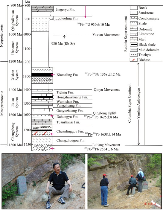
[Figure: The column of the Mesoproterozoic and Neoproterozoic strata in the Jixian section (Jixian County, Tianjin Municipality) with inferred regional tectonic episodes (movements). The Changzhougou Fm is at the base of this important reference section for the Mesoproterozoic systems of China. [See Chuanlinggou Fm for geologic location map]
Relationships and Distribution
Lower contact
The base of the formation is in unconformable contact with underlying stratigraphic units, for example by the Zunhua Gr and the Qinglonghe Gr in Yanshan Mountains, by the Gantaohe Gr, in middle segment of Taihang range, and Jianping Gr in western Liaoning Province. Schematic stratigraphic column shows it overlying a Qian Gr of Archean.
Upper contact
It has a conformable contact with Chuanlinggou Fm
Regional extent
North Hebei-western Liaoning. The Changzhougou Fm is widely distributed in northern Hebei and western Liaoning Province. But it is greatly variable in thickness. In Lingyuan County, western Liaoning, its thickness varies from 128 to 1600 m, but it thickens to northeast direction, for example in Kuancheng area the maximum thickness reaches 1390 m, where it is sandwiched with silty shale nearly 80 m thick in middle part. It is inferred that the Jixian County was the deposition center, and the formation thins gradually to the west, even lacks some stratigraphic horizons.
GeoJSON
Fossils
It bears microplants: Leioarachnitum, Macroptycha, Kildinella, and Leiominuscula.
Age
Depositional setting
Additional Information
The paleomagnetic polarity of the formation is positive, and the paleomagnetic pole position was located at 28.2°N, 226.8° E (Zhang Huimin et al., 1991).
